Tuleyome's Science Corner - Lichen

Geoffrey Benn • August 21, 2023

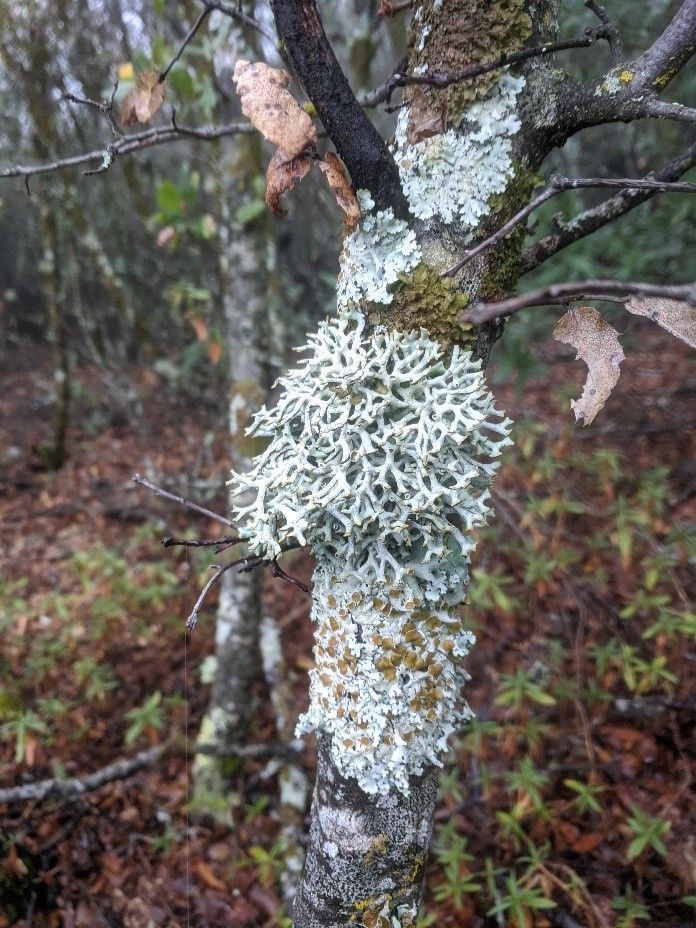
Oak Moss Lichen on a tree near the Dunfield Spring Trail in Berryessa Snow Mountain National Monument. Photo by Geoff Benn

The Berryessa Snow Mountain National Monument is home to a wide variety of lichens, ranging in appearance from drab flattened circles on rocks to wild filamentous and spiky forms that festoon trees. Among the latter category is our newly minted state lichen, the Lace Lichen, which can be seen in great numbers dangling from the branches of oak trees along Highway 128 south of Lake Berryessa.


So, what are lichens anyway? They’re actually not a single organism but are instead a long-term symbiosis between two different species – a fungal partner and a photosynthetic partner, which can be either a green alga or a cyanobacteria. Most of the body of a lichen is comprised of fungal filaments called hyphae, with a thin layer containing the photosynthetic partner just underneath the upper surface. The hyphae of the fungi wrap tightly around the individual cells of the photosynthetic partner, enabling the transfer of materials between the two species. There is still some debate about the exact nature of the relationship between the two partners, but the most commonly held view is that it is a mutualistic association where the photosynthetic partner provides sugars to the fungi and receives a protected place to live in return.


There are over 1900 species of lichen in California, with each adapted for growing on different types of surfaces, including species that specialize on desert soil, newly exposed rock, or living on trees. Lichens excel at living in these challenging environments because they can dry out almost completely and then revive once moisture returns. In fact, researchers with the European Space Agency exposed lichens to the vacuum of space for 14 days and found that they grew normally afterwards.


Lichens play an important role in the weathering of rocks by secreting chemicals that slowly break down the rocks, contributing to the formation of new soil. These rock dwelling lichens tend to be extremely slow-growing species that may grow at rates of only 1-2mm per year. Scientists have taken advantage of this fact by developing the field of lichenometry, which uses the growth rates of lichens to estimate the age at which a rock was first exposed to the surface. These techniques are particularly useful for dating surfaces that are 500 years or younger, where radiocarbon dating tends to be less effective.

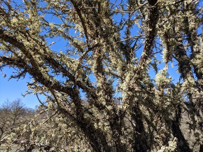
Several species of lichen on a tree on the Fiske Peak Trail in Berryessa Snow Mountain National Monument. Photo by Geoff Benn

In addition to rock-dwelling lichens, species that grow on trees are very common in the Berryessa Snow Mountain National Monument. One of the most common is the Oak Moss Lichen, which I frequently see on Blue Oaks in the area. Unlike the parasitic mistletoes that also grow on oaks, lichens don’t harm the trees and only use them as a surface to grow on. Lichens may be more prevalent on dead or dying trees – this is likely due to the increased availability of sunlight due to the lack of leaves on the tree.


Lichens are also an important indicator of air quality. This is because they must absorb their nutrients from the air and are thus particularly sensitive to air pollution. This sensitivity is one reason why lichens tend to be uncommon in urban areas.

If you’ve been lichen this article, you can learn more about lichens in the Berryessa Snow Mountain National Monument by visiting iNaturalist.


-Dr. Geoff Benn (gbenn@tuleyome.org)


Education Associate


RECENT ARTICLES

By Bryan Pride February 11, 2026
In 2020, Governor Newsom committed California to an ambitious goal: conserve 30% of our lands and coastal waters by 2030. This “30x30” initiative isn’t just about setting aside more protected areas; it’s a comprehensive strategy to protect biodiversity, expand equitable access to nature, and build resilience to climate change across California’s diverse landscapes and waters. California has made meaningful progress towards the 30x30 goal. Currently, 24.4% of our lands and 16.2% of coastal waters meet the 30x30 conservation criteria, defined as areas that are durably protected and managed to sustain functional ecosystems and the diversity of life they support. But with less than five years remaining, we still need to conserve millions of additional acres to reach this critical goal. The Power In Nature Coalition No single organization can achieve 30x30 alone. That’s why Tuleyome is a proud member of the Power In Nature Coalition; a network made powerful by the collective work of over 250 community groups, conservation organizations, land trusts, and Indigenous organizations working together to conserve and protect the diverse landscapes of California. This statewide network coordinates advocacy, identifies priority conservation projects , and ensures that 30x30 implementation protects biodiversity, fosters meaningful relationships, and partners with state agencies and diverse communities. Power In Nature works on multiple fronts: defending conservation funding in state budgets, identifying potential 30x30 projects across California, and advocating for policies that support rather than undermine conservation progress. Power In Nature has multiple regional groups to elevate geographical priorities and empower local organizations to connect state-level policy to on-the-ground conservation work in their communities. Tuleyome’s Role in Advancing 30x30 At Tuleyome, our work protecting the Berryessa Snow Mountain National Monument directly contributes to California’s 30x30 goals. We’re actively engaged with Power In Nature’s Sacramento Valley regional group, as well as the Far North and Bay Area regional groups, helping coordinate conservation efforts across our region and connecting local priorities to statewide advocacy. Tuleyome has also participated in Power In Nature Advocacy Days, where we met with state elected officials to discuss policies and legislation that further or hinder the 30x30 conservation goals. How You Can Support 30x30 Whether you’re a landowner, community member, or fellow conservation advocate, there are many ways you can support 30x30 progress. There are multiple qualifying conservation lands that have not been added to the Conserved Areas Explorer and this is one of the many ways people can get involved to help track areas protected. If you’re interested in learning more about 30x30 activities in your region, check out the Power In Nature regional groups and sign up to attend monthly regional meetings or gain access to Power In Nature’s newsletter. Most importantly, through Power In Nature, you can make your voice heard by participating in local advocacy days or contacting your state legislators to encourage their support for full funding to conservation agencies and protection of environmental review processes. California’s commitment to conserve 30% of our lands and waters by 2030 is achievable, but only if we work together to make it a reality. If you have questions about how to get involved with 30x30 or Power In Nature, don’t hesitate to reach out! Bryan Pride Tuleyome Policy Director
By Kristie Ehrhardt February 11, 2026
You might already know that the Berryessa Snow Mountain National Monument (Monument) is a wonderland for birdwatchers. With a range of habitat types from aquatic, riparian, native grassland, oak woodlands, conifer forests to subalpine the range of species found in the Monument is staggering. If you prefer to break it down by county rather than habitat, western Colusa County boasts a birders paradise in Bear Valley and Lake County offers the shores of Clear Lake. Napa County showcases Quail Ridge Reserve and Lake Hennessey. Yolo County puts forth a plethora of hot spots including Putah Creek, Lake Solano, and the Cache Creek preserve which is home to Bald and Golden Eagles, Osprey and others! And, this is just a smattering of the treasure trove for bird nerds to enjoy in the nearly 345,000 publicly accessible acres of Monument. But, how do you know where and when to go to see what? Even if you’re an experienced birder, it can be overwhelming to know where and when to begin. I know people that travel to different states to check birds off of their “life list”. I also know people, some of them are those same people, that travel all over the globe to get a glimpse of a rare bird - or maybe it’s just rare to someone from Sacramento. Either way it’s enticing and rewarding to be part of a community with a common interest. There’s almost a secret code between birders. There’s definitely a code to name abbreviations and a spiffy way to keep count if you’re recording them. There’s also a way to estimate the number of birds in a flock but if you’re just wanting to sneak up on a feathered friend near or far, how do you know where to start? Try downloading the Cornell Lab eBird app. The app lets you input your own findings as well as investigate other people’s observations. You can base your search on your location or use a near or far location that you’d like to go explore. Or, you can browse by species and see exactly where to go to find them. The eBird app uses citizen science and operates similarly to the iNaturalist app, a favorite among biologists, naturalists and other interested folks. With the eBird app, you can contribute your sightings or even sound recordings to the community platform making it the largest birding community in the world. You can also create your own lists and have the app track them for you. The app not only makes birding more inclusive and interesting for individual birders but it is beneficial for the network of scientists as well. The combined data from the app helps conservationists understand how numbers of birds shift as well as aiding in developing genetic species distribution models that show where and when birds are in the region. This information helps develop and establish better conservation strategies for individual species and collective populations of birds. The app is easy, fun and rewarding for novice and veteran birders, conservationists, scientists and ultimately the birds themselves.
By Kristie Ehrhardt February 11, 2026
The Capay Valley Almond Festival has been a regional tradition since 1915. It showcases the Esparto/Capay Valley region and was originally held in the fall after the almond harvest was complete. Years later it was rescheduled to occur on the last Sunday in February to celebrate the almond trees while in blossom. The Almond Festival is the only local celebration that not only incorporates the dazzling landscape but it also honors five Capay Valley towns: Esparto, Capay, Brooks, Guinda and Rumsey. The 21-mile route along Highway 16 covers each town, offering their own unique ambiance and activities all while celebrating the almond bloom in Yolo County. You will also find local crafts, family fun, delicious food and other entertainment at each location. A bit about California’s almond history! Much like the European Starling’s initial introduction into the United States, the first attempt at almond production in California was not as glorious as anticipated. Almond trees were first planted in California as early as 1853 using European varieties that were not adapted for our climate conditions. Most of these subpar trees were either converted into other fruit trees or used for firewood. Even though the inaugural attempt wasn’t fruitful (haha, get it?), lessons were learned about cross pollination and where to plant the next go-around. Science happened and by the 1880’s other varieties were being cultivated and during the Citrus Fair in 1886, the two varieties that are still grown today were introduced. By the 1900’s cross pollination tactics advanced and were in place and our commercial production was on its way. This combined with the fact that almond trees were productive in soils that were too sandy for other fruit trees and could be prolific without the use of much artificial water, the crop finally seemed to be destined for success. During the twenty year span between the mid 1960’s and the mid 1980’s, irrigation methods advanced and became more available to land in the San Joaquin Valley, which held ideal conditions for almond production, creating a booming industry that still remains today. In 2020, 1.25 million acres of California were in almond production. We yield 2.8 BILLION (!) pounds of almonds which provides 100% of the United States commercial supply and over 80% of the world’s demand. Almonds are in the top five most valuable California exports bringing in almost five billion dollars.