Monumental Questions - Cache Creek Bridge Brings Opportunity for Recreational Renewal

Andrew Fulks • December 5, 2022

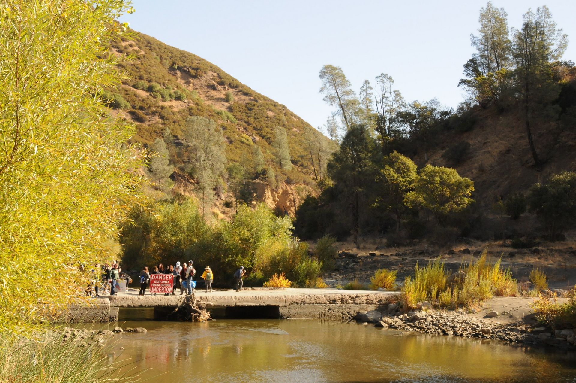
The old bridge over Cache Creek, which only allowed foot traffic, has been replaced!

With news that the Road 40 (aka. Rayhouse Road) bridge over Cache Creek is complete, it is important that people realize both the opportunities as well as the challenges that come with it being almost 14 years since the original bridge was condemned. One of the issues with areas that have reduced public and maintenance access over such a long time is that many if not all of the people in charge of management of the area have moved on or in some cases, have passed away. Their successors won’t necessarily know the backstory of an area and what needs to take place after the access issue has been resolved. They, and even much of the general public, won’t know the historical context of the area and may only be familiar with the current conditions, not how the area was before the bridge was condemned.


Though not yet a National Monument, in 2008 the Fiske Creek canyon area of the Blue Ridge in Yolo County was a hub of recreation opportunity for residents of the region. Yolo County has the Lower Cache Canyon Regional Park day use area next to the creek where the rebuilt bridge crosses. Before 2008, BLM actively managed the canyon lands as well as a number of trails, including the Blue Ridge Trail north and southFiske Creek Trail, and Frog Pond Trail. There was a primitive camp at the south end of the Fiske Creek Trail along Fiske Creek Road, complete with concrete fire pit and picnic table. The Blue Ridge South Trailhead was reachable by 2-wheel drive car back then. Buck Island campground, a remote wilderness camp along Cache Creek at the end of Langs Peak Road was a draw for family camping. BLM invested hundreds of thousands of dollars into the Buck Island campground and it features two precast concrete restrooms. Buck Island was also the put-in for two rafting concessions, allowing them to run two-day wilderness trips that explored different parts of the river between days.


Then, in 2008, Caltrans condemns the low-water bridge over Cache Creek as the footings are undermined. This is also the year of the financial crisis, so Yolo County, no longer able to cross the bridge with a road grader, opts to cease maintenance of Rayhouse Road. BLM, also unable to cross the bridge and with Rayhouse Road now unmaintained, can no longer get a road grader to the upper areas to maintain Fiske Creek Road and Langs Peak Road to Buck Island. BLM can’t get inmate crews up to the Fiske Creek Trail or Blue Ridge Trail South trailhead, as busses can no longer travel over the bridge or the unmaintained Rayhouse Road. Volunteer crews can’t feasibly access the Fiske Creek and Blue Ridge South trailheads to maintain the trails, as they are many miles away and the day would be done by the time one was able to walk the old road to the trailhead.


This inability to cross the bridge, which led to lack of maintenance on the dirt Rayhouse Road, begins the downward spiral of recreation opportunities and management. Rayhouse Road suffers from massive erosion as winter rains and runoff plug the culverts, causing flow across the road and vertical eroded edges where it travels down the bank. The same thing happens on BLM’s Fiske Creek Road and Langs Peak Road, rendering them impassible. Lacking the maintenance from inmate and volunteer crews due to vehicle inaccessibility, Blue Ridge Trail south of Fiske Peak becomes overgrown and almost impassable. Fiske Creek Trail suffers the same, with overgrown brush making it very difficult find and to follow. Buck Island, now only accessible by motorcycle or quad and no longer having active ranger patrols, begins to see vandalism. The rafting concessions lose a quarter of their business, as they can no longer offer the 'wilderness' overnight trip. Marijuana growers move into Fiske Creek Canyon and near New Cacheville, as the Sheriff no longer patrols the area. Several fires, including the 2009 Oasis fire and 2015 Rocky and Jerusalem fires are difficult to access due to the lack of a bridge. A portable pontoon bridge is installed to allow firefighting efforts during the 2015 fires as well as the 2018 County fire. CalFire grades Rayhouse Road, but only for fire suppression efforts during those events, so it washes out immediately after the rains begin as the grading is not performed with longevity in mind.


Yolo County and Tuleyome began pushing for bridge replacement almost immediately after it was condemned in 2008, but it was the subsequent fires that made the bridge a priority. Thanks to our State Representatives, funding was secured for the design and replacement of the bridge. In 2020, construction is began on a replacement and the bridge has just been opened! 


The bridge replacement gives us the opportunity to restore management and recreation opportunities in the Fiske Creek Canyon area of the Berryessa Snow Mountain National Monument.


There are opportunities such as:


*Yolo County can now access Rayhouse road and resume maintenance


*BLM can restore maintenance of Fiske Creek Road and Langs Peak Road, now that Rayhouse Road will be again accessible


*Once Fiske Creek Road is restored, Fiske Creek Trail and Blue Ridge Trail south can be brushed, re-opening the trails for the public.


*Frog Pond Trail can be rebuilt after damage from CalFire during the County Fire last summer.


*Fiske Creek Campground can be re-opened.


*Buck Island will again be usable for the general public via access from Highway 16.


However, with an almost entirely new BLM and County staff, there isn’t an internal push to repair and re-open all of the trailheads, campgrounds, and access roads that can be restored after the bridge is replaced. It is up to us to advocate for repair and restoration of this amazing recreational resource, and let our leaders and land managers know we want to regain what we had 14 years ago.


This area is a substantial part of the National Monument, the only part of the monument accessible within Yolo County, and is a beloved public resource. I am hoping the replacement of the bridge spurs both conversation and action between BLM, Yolo County, and non-profit groups like Tuleyome, to prepare for future public use of the area. A plan is needed to deal with the increased public access that will result from the bridge begin restored. Working together, we can make the area like it was prior to 2008, or even better! With restored public recreational access, and with access for ranger and sheriff patrols, the public and natural resources will benefit from completion of the new Road 40 bridge over Cache Creek!


-Andrew Fulks


Tuleyome Advisory Council Member

RECENT ARTICLES

By Bryan Pride April 4, 2025
A lot has happened in the Public Lands space since our last Policy Corner. Doug Burgum took his role as the 55th Secretary of the Interior, and Kathleen Sgamma received confirmation to head the Bureau of Land Management (BLM). The House Natural Resources Committee has held several oversight hearings on topics ranging from selling off public lands to establish American Energy Dominance , defunding federal agencies such as BLM as a method to incentivize Multiple Land Use by private companies and undercutting the efficacy of the Endangered Species Act (ESA) and calling it a “needed reform”. Through questionable actions made by DOGE, we have also seen thousands of Forest Service, BLM and National Park employees fired and, through court order, rehired . With all this chaos happening far and near, the real question becomes: What does all this chaos mean for Californians? Bureau of Land Management (BLM) land is concentrated in 12 western states. California holds nearly 15 million acres of BLM lands. In addition to BLM land, California has land that is managed by other federal agencies such as the U.S. Forest Service, National Park Service, and U.S. Fish and Wildlife Service. The recent reductions to staff across all federal agencies directly impacts National Monuments, National Parks, and National Forests, that are located within California. Every year, Californians, residents from nearby states, as well as international tourists visit the public lands within California as a way to spend time with families, enjoy the great outdoors, and experience mental healing. The National Park Service reported that 36.2 million people visited the 28 national parks in California in 2023 . Those visitors spent roughly $3.2 billion dollars, which supported 39,678 California-based jobs and contributed $5.1 billion dollars to our state economy. While it may not be as visible, the presence of BLM and U.S Forest Service also creates jobs in California and positively contributes to the local economies of our communities and the overall economic strength of California as a whole. Public Lands are more than recreation; they create employment opportunities and contribute to economic prosperity. Despite National Monument and public lands holding immense value in the hearts and minds of Californians and the American people in general, our public lands are being threatened. It was announced earlier in the month that DOGE plans to close federal offices across the United States. One of the offices that has been targeted to close is the Ukiah BLM office . The Ukiah BLM office plays a significant role in coordinating protection for the federal lands in California ranging from the intercostal mountain range and Berryessa Snow Mountain National Monument, which includes the Mendocino forest. The Ukiah office assists with issuing permits for timber harvesting, livestock grazing, off highway vehicle recreation, and overseeing proper adherence to environmental preservation practices. Additionally, Ukiah is essential in coordinating CalFire dispatch and response to the wildfires that affect our forests and our communities. The Ukiah BLM office also houses the Berryessa Snow Mountain National Monument Manager. Without a Ukiah office, the Monument Manager's ability to respond to fires, guarantee safety, and ensure that conservation practices are taking place in and around the monument is reduced. This means that our public lands and forests are at heightened risk of wildfires and trails we love to hike become unsafe to those who use them. The closure of the physical office is not the only threat to Ukiah BLM operations. Many of the staff have been in their posts for years and have recently been promoted, meaning the invaluable staff is at risk of being terminated due to their probationary status. We run the risk of losing these public servants and the institutional knowledge they have of our public lands. 1.5 million Californians throughout the region will be affected if we lose the Ukiah office or staff. The Department of Interior (DOI) is also proposing selling an area of federal land larger than the city of Los Angeles as part of the agency's plan to use public lands to help solve the recently announced "housing and energy crisis." The DOI is looking to sell about 400,000 acres—625 square miles—of federal lands for housing. Federal lands that are within a radius of up to 10 miles of all cities and towns with a population greater than 5,000 people are at risk of being sold to private companies. This has the potential to affect communities that are near the Berryessa Snow Mountain Monument. When private companies have ownership of land that surrounds protected landscapes, public access to National Monuments is reduced, oversight on how once-public lands are managed is lost which has the potential to result in the destruction of monuments such as the Berryessa Snow Mountain. With so much going on in the Public Lands and Conservation space, Tuleyome is working hard within our networks to fight against policies that put our public lands at risk. For the past several weeks, we have connected with both Congressional Offices and members of the California State Legislature, asking our representatives to be advocates for our public lands and promote good land stewardship. On March 18th, Tuleyome joined the California Power in Nature Advocacy day, where we, along with 80 other organizations throughout California, gathered in Sacramento to advocate for policies that prioritize the protection of California Public Lands and Coastal Waters. This was an opportunity for Tuleyome to amplify the voices and concerns that many of us have regarding public lands and the importance of prioritizing land protection. We were well received by California Legislators and hope to see statewide initiatives that strengthen conservation practices and promote good land stewardship. Reaching beyond a state level, Tuleyome is partaking in a Conservation Lands Foundation advocacy Fly-in where I will be visiting Congressional Representatives in Washington D.C. and advocating for the importance of: public lands remaining public, the necessity to reinstate park rangers and other public servants in our U.S. Forest Service, and Bureau of Land Management offices. Our visit to Washington will feature stories and connections about how we enjoy our public lands as outdoor enthusiasts, community members, botanists, and individuals whose livelihoods are dependent on public lands. Each time we engage in these efforts, Tuleyome is representing our diverse community and advocating on behalf of the land we love, but we could still use more help in amplifying the importance and love of our public lands. I want to thank everyone who has been emailing and asking how to help advocate for our public lands. All of us have the ability to advocate for keeping our public lands in the hands of the public; together, we have strength, and we can amplify our voices. For those of you who are interested in getting involved, there are many ways to help out. Some of the most impactful efforts include calling your state and federal representatives. Elected officials want to hear from you. Calling elected officials leads to impact; each call is documented and reviewed. It is one of the best methods for elected officials to keep record of what their constituents care about. I want to urge our readers to call your representatives, and it's okay to call multiple times. Each time you call, it is documented and demonstrates the urgency associated with the cause. Even if you called once before, call again and keep calling. Reaching out to friends, family members, and community groups and encouraging them to call their representatives is a powerful way to advocate. Don't know who your representative is? No problem—use these links to find both state and federal representatives by using your zip code. You can also send letters to elected officials. Using this link , you have the chance to send a letter to your elected officials and customize what you want to say about public lands. We encourage folks to use these grassroots options and join the fight to keep our public lands public. All of us have the ability to advocate for our public lands and its resources – wildlife, flora, fauna, water and culture. If you're interested in learning more ways to help raise awareness and advocate for your public lands, feel free to reach out to me. Until then, Happy Hiking! -Bryan Pride ( bpride@tuleyome.org ) Policy Director
By Kristie Ehrhardt April 4, 2025
We know how special Molok Luyuk is; to the indigenous people that call it home, to those of us who visit it regularly and for posterity. With 500 different types of plants - 40 of them rare, Bald and Golden Eagles, Tule Elk, unique soils and fascinating geology, we already knew that Molok Luyuk deserved to be protected inside the Berryessa Snow Mountain National Monument boundaries. And now, it's getting some well-merited attention from BayNature.org . Check out what they have to say about one of our favorite places! -Kristie Ehrhardt ( kehrhardt@tuleyome.org ) Tuleyome Land Conservation Program Manager
By Kristie Ehrhardt April 4, 2025
You’ve probably enjoyed at least some portion of National Conservation Lands and may have not even known it. Primarily focused in the western United States, National Conservation Lands comprise over 38 million acres that includes California Desert, Conservation Areas, National Monuments, National Scenic and Historic Trails, Wilderness Areas, Wilderness Study Areas, and Wild and Scenic Rivers. With such a vast collection you can imagine the landscape and artifacts found in the National Conservation Lands program varies greatly ranging from brawny Alaskan tundra, dynamic coastlines, enchanting red-rock deserts, noble historic lighthouses, intricate waterways and serene mountains. National Conservation Lands provide public access to recreational and scientific research opportunities along with protected critical habitat for sensitive species and wildlife migration corridors. While some of the National Conservation Lands are remote, so much that for thousands of years they were protected just by their location or accessibility. Other National Conservation Lands are nearby and easily accessed, especially now that today one in six people live within 100 miles of federally protected public land. The National Conservation Lands program was created in 2000 by conservationists in response to mounting threats to cultural resources, waterways and public lands managed by the Bureau of Land Management (BLM). The BLM currently manages roughly 245 million acres of public land, more land than any other agency in the United States. But, only about 15%, around 37 million acres of those protected areas are designated as National Conservation Lands - lands that possess some of the last remaining wild, ecologically sensitive and culturally rich areas in the Western United States. They are often described as the landscape between more commonly known and familiar public lands such as National Parks and National Wildlife Refuges. Protecting these “in between areas” means safeguarding large, intact landscapes, ecosystems and culturally rich areas as one unit. These areas are managed to honor the ties that indigenous communities have to their lands while also embracing diverse interests and uses for future generations. The National Conservation Lands Foundation was formed in 2007 and combined a local grassroots network with a sophisticated national presence to permanently protect more land as well as offer support to other like-minded community-led organizations and advocates who all share a love of public lands. Today, the National Conservation Lands program includes 28 National Monuments (including our favorite, The Berryessa Snow Mountain National Monument), 25 National Conservation Areas, 21 million acres of Wilderness and Wilderness Study Areas, 2,700 miles of Wild and Scenic Rivers and 6,000 miles of Historic Trails. Not bad for only 25 years worth of work! To learn more about National Conservation Lands in California visit : https://www.blm.gov/programs/national-conservation-lands/california To learn more about our friends at Conservation Lands Foundation visit : https://www.conservationlands.org/ -Kristie Ehrhardt ( kehrhardt@tuleyome.org ) Tuleyome Land Conservation Program Manager